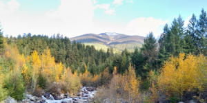
A ski resort at Garibaldi has been proposed since late last century. Since then, there has been a raise in both environmental concern and snowlines. The importance of preserving habitat has become clearer, and winter ranges mapped. What will be the environmental impact of Garibaldi with the standards of a new generation?
For this project, I looked at the proposed area of the Garibaldi Resort, taking into account environmental issues such as protection of streams, protection of the winter ranges of ungulates, and old growth forest.
Process
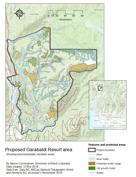 I created buffers around streams to show areas needed to protect the bank from damage and the stream's wildlife from deterioration of the immediate environment. The buffers varied in width, according to altitude, assuming that larger streams at lower altitudes need a wider protective buffer (50m buffer above 600m, 100 below). I added the areas of old-growth forest and winter range of mountain goats and mule deer to the map. I took the intersection of these three areas to find the protected area in the proposed resort. I also showed the snowline, extending it beyond the resort boundaries to show the nature of the context. I showed existing roads, and some surrounding area. Part of the proposed resort is surrounded by park land, and part is private land. I considered shading the parkland differently, and showing the ungulate winter range and old-growth forest areas in the park as well, but decided that this information did not contribute to the analysis. I simplified the map by leaving it out. I used logically associated colours for the legend items (blue for water-related areas, dark green for forests, brown for animals). Finally, I created an inset map to show where in British Columbia the proposed resort area is.
Conclusion
The resort would need to build in areas that did not impact these sensitive areas. However, these areas comprised a total of about 38% of the proposed resort area. Not only that, but given that stream banks need protection, the natural lay of streams are likely to block the logical areas for development. Long bridges would be required, and ski runs would be very difficult to lay out in ways that did not damage sensitive environmental areas.
In this assignment, I learned to go through the seven stages of visualising data described by Ben Fry:
1. Acquire – I obtained data from freely available and from restricted sources
2. Parse – I re-projected and reclassified the data for analysis
3. Filter – I selected data to show the issues and area of interest
4. Mine – I used GIS analysis to make context of data clear, including buffers and dissolving polygons, and summary statistics.
5. Represent – I created a simple map of critical areas to use as a base for more complex maps
6. Refine – I created more specific and attractive maps
7. Interact – I reflected on the data and maps to show only important features, and wrote up the results